| Magnitude | 5.3 |
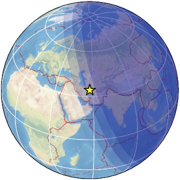
| Region | NORTHEASTERN IRAN |
| Date time | 2022-12-13 14:14:27.1 UTC |
| Location | 34.006 ; 57.253 |
| Depth | 2 km |
| Distance | 222 km WNW of Bīrjand, Iran / pop: 196,000 / local time: 17:44:27.1 2022-12-13 55 km NNE of Tabas, Iran / pop: 49,900 / local time: 17:44:27.1 2022-12-13 |
All data providers for this event:
Geoscience Australia, Canberra, ACT, Australia -- Canberra, Australia (AUST)Rede Sismografica Brasileira -- Sao Paulo, Brazil (RSBR)
Seismological Survey of Serbia -- Belgrade, Serbia (BEO)
GeoForschungsZentrum (GFZ) -- Potsdam, Germany (GFZ)
Republican Seismic Survey Center or Azerbaijan National Academy of Sciences -- Baku, Azerbaijan (RSSC)
National Earthquake Information Center, U.S. Geological Survey -- Golden, United States (NEIC)
Institute of Geophysics, University of Tehran -- Tehran, Iran (IGUT)
National Institute for Earth Physics -- Bucharest, Romania (NIEP)
Ukrainian NDC, Main Center of Special Monitoring -- Kyiv, Ukraine (MCSM)
ELKH EPSS Kovesligetyh rado Seismological Observatory -- Budapest, Hungary (BUD)
International Institute for Earthquake Engineering and Seismology -- Tehran, Iran (IIEES)
Geophysical Survey of the Russian Academy of Sciences -- Obninsk, Russia (GSRAS)
Kandilli Observatory and Earthquake Research Institute -- Istanbul, Turkey (KOERI)
Further information can be found at:
Geophysical Survey of the Russian Academy of Sciences -- Obninsk, Russia (GSRAS)Institute of Geophysics, University of Tehran -- Tehran, Iran (IGUT)
International Institute for Earthquake Engineering and Seismology -- Tehran, Iran (IIEES)