| Magnitude | 5.3 |
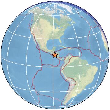
| Region | NEAR COAST OF NICARAGUA |
| Date time | 2023-02-27 18:46:05.6 UTC |
| Location | 12.654 ; -88.005 |
| Depth | 53 km |
| Distance | 94 km SSE of San Miguel, El Salvador / pop: 161,000 / local time: 12:46:05.6 2023-02-27 65 km SSE of Chirilagua, El Salvador / pop: 6,300 / local time: 12:46:05.6 2023-02-27 |
All data providers for this event:
Universidad de Panama -- Panama, Panama (IGC)Geoscience Australia, Canberra, ACT, Australia -- Canberra, Australia (AUST)
Rede Sismografica Brasileira -- Sao Paulo, Brazil (RSBR)
Ukrainian NDC, Main Center of Special Monitoring -- Kyiv, Ukraine (MCSM)
Instituto Nicaraguense de Estudios Territoriales -- Managua, Nicaragua (INET)
GeoForschungsZentrum (GFZ) -- Potsdam, Germany (GFZ)
Geophysical Survey of the Russian Academy of Sciences -- Obninsk, Russia (GSRAS)
Kandilli Observatory and Earthquake Research Institute -- Istanbul, Turkey (KOERI)
National Earthquake Information Center, U.S. Geological Survey -- Golden, United States (NEIC)
Further information can be found at:
National Earthquake Information Center, U.S. Geological Survey -- Golden, United States (NEIC)Servicio Sismologico Nacional, Instituto de Geofisica, UNAM -- Mexico City, Mexico (UNM)
Servicio Nacional de Estudios Territoriales (SNET El Salvador) -- San Salvador, El Salvador (SNET)
Seccion de Sismologia, Univ. de Costa Rica, San Jose, Costa Rica -- San Jose, Costa Rica (UCR)
GeoForschungsZentrum (GFZ) -- Potsdam, Germany (GFZ)
Instituto Nicaraguense de Estudios Territoriales -- Managua, Nicaragua (INET)