| Magnitude | 7.1 |
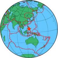
| Region | BOHOL, PHILIPPINES |
| Date time | 2013-10-15 00:12:33.0 UTC |
| Location | 9.921 ; 124.104 |
| Depth | 15 km |
| Distance | 46 km SE of Talisay, Philippines / pop: 133,000 / local time: 08:12:33.0 2013-10-15 15 km NW of Carmen, Philippines / pop: 8,200 / local time: 08:12:33.0 2013-10-15 |
All data providers for this event:
Instituto Geografico Nacional -- Madrid, Spain (IGN)National Institute for Earth Physics -- Bucharest, Romania (NIEP)
Japan Meteorological Agency Seismic Network -- Tokyo, Japan (JMA)
Geophysical Institute of the Academy of Sciences -- Prague, Czech Republic (GFU)
Montenegro Seismological Observatory -- Podgorica, Montenegro (MSO)
GeoForschungsZentrum (GFZ) -- Potsdam, Germany (GFZ)
Norwegian Seismic Array -- Lillestrom, Norway (NORSAR)
Alaska Tsunami Warning Seismic System, West Coast and Alaska Tsunami Warning Center -- Anchorage, United States (AT)
Pacific Tsunami Warning Seismic System, Pacific Tsunami Warning Center, Ewa Beach, Hawaii -- Ewa Beach, United States (PT)
Geophysical Survey of the Russian Academy of Sciences -- Obninsk, Russia (GSRAS)
National Earthquake Information Center, U.S. Geological Survey -- Golden, United States (NEIC)
GeoSphere Austria -- Vienna, Austria (GSA)
Pacific Tsunami Warning Center -- Honolulu, United States (PTWC)
Further information can be found at:
GeoForschungsZentrum (GFZ) -- Potsdam, Germany (GFZ)National Earthquake Information Center, U.S. Geological Survey -- Golden, United States (NEIC)
Philippine Inst. of Volcanology and Seismology, Quezon City, Philippines -- Manila, Philippines (PIVS)