Mw 5.1 LORCA (Spain) on May 11th 2011 at 16:47 UTC
Last update: 6 July 2011 at 14:01 UTC
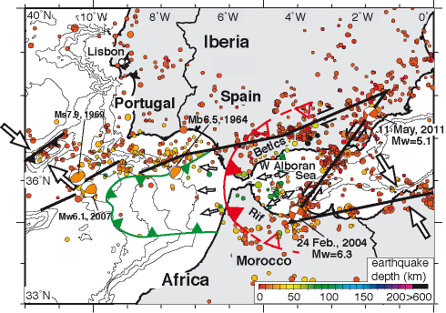
On May 11th 2011 at 16:47 UTC (18:47 local time), an earthquake of magnitude Mw 5.1 occurred near the city of Lorca, in the South East of Spain. It was largely felt along the Mediterranean Coast, in Murcia and up to Valencia, more than 200km away. Information on this main shock is available here. Ten casualties and significant damage has been reported in Lorca, a city of 90,000 inhabitants. Details on this event and the recent seismicity are available on the Spanish institute (IGN) website. Live information is also available on the RTVE.
The earthquake was preceded by another significant event of magnitude 4.5 at 15:05 UTC and followed by 4 aftershocks of magnitude larger than 2.5 in the 4 hours following the main shock. The region had been previously hit by an earthquake of magnitude 4.4 on January 29th 2005, leading to moderate damage. This 2005 event occurred only 40km away from the May 11th 2011 event. The Murcia region has been affected by five important earthquakes in the last 12 years, related to the Alhama fault activity. The two largest occurred in February 1999 in Puebla de Mula and in August 2002.
Field reports
A very interesting Field report that explains the damage in Lorca by studying the behavior of the different types buildings during the shake by P. Murphy Corella.
Field reports by the Association Française du Génie Parasismique (AFPS) <New !>:
- Field report
- AFPS special web page (in French)
Where you there?
If you experienced this earthquake, you are invited to answer the online questionnaire. Your report will be useful to update the Intensity map below, where intensities correspond to the effects of the earthquake. You can also read the comments posted by people who experienced this event or view them on the interactive map here below.
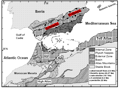
Tectonic settings
The limit between the African and Eurasian plates follows a seismic line which begins in the Azores and ends on the Western side of the Gibraltar Strait where major historical earthquakes occurred (such as the Lisboa earthquake 1755). To the East, the deformation spreads in two directions, in Southern Spain in the Betics Chain and in the Maghreb area. The seismicity is representative of continental collision.
 |
 |
| by Calvert et al., 2000 | by Gutscher, 2004, Science |
Recent scientific articles
Study of the 6 June 1977 Lorca earthquake and its aftershocks sequence by Mezcua et al. BSSA; 1984
Study of the Damaging Earthquakes of 1911, 1999, and 2002 in the Murcia region. Seismotectonic and Seismic-Risk Implications by Buforn et al. BSSA; 2005
The Bullas (Murcia, SE Spain) earthquake, 29 January 2005 by Buforn et al. Journal of Seismology; 2006
Moment tensor solutions for small and moderate earthquakes in the Ibero-Maghreb region by Stich et al. JGR; 2003
Kinematics of the western Med. : New GPS constraints on deformation along Africa-Iberia plate boundary by Idrissi et al. EGU 2011
Moment tensor inversion for Iberia–Maghreb earthquakes 2005–2008 by Stich et al. Tectonophysics; 2009
The Alhama de Murcia fault (SE Spain), a seismogenic fault in a diffuse plate boundary: Seismotectonic implications for the Ibero-Magrebian region by Masana et al. JGR; 2004
Large Holocene morphogenic earthquakes along the Albox fault, Betic Cordillera, Spain by Masana et al. JGR; 2005
Stress field variation related to fault interaction in a reverse oblique-slip fault: the Alhama de Murcia fault, Betic Cordillera, Spain by Martinez-Diaz Tectonophysics; 2002
Miocene extensional basin development in the Betic Cordillera,SE Spain revealed through analysis of the Alhama deMurcia and Crevillente Faults by Meijninger and Vissers Basin Research; 2006
Focal mechanism
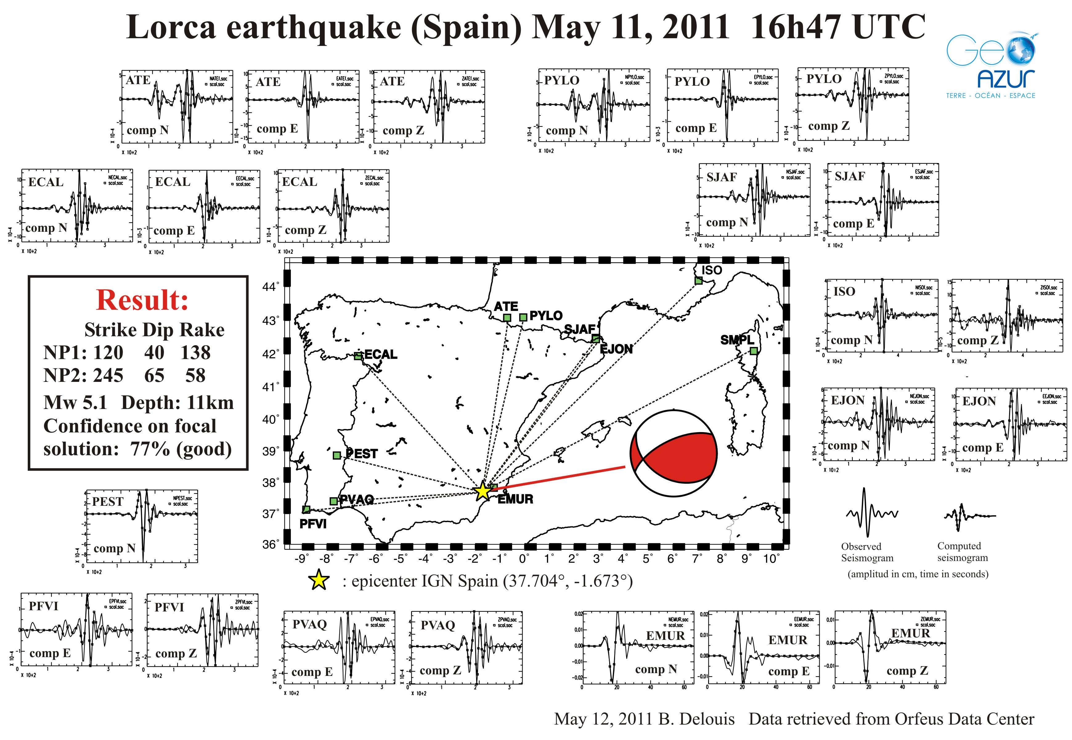 |
 |
| by B. Delouis (GeoAzur) |
Double couple solutions from other agencies |
Aftershocks locations
Intensity map and felt map

Left: Macroseismic map based on eye-witness reports to our questionnaire.
Right: Location of the EMSC web site visitors in the 5 minutes after the earthquake occurrence.
This shows that the earthquake has been widely felt on the Eastern Coast of Spain.
Comments posted by the witnesses
You can click on the map' icons to view specific information.
Send us pictures or videos
You were on the spot and you have taken photos or videos of earthquake effects (on buildings, ground, landscape), please send us your files. Send them by mail, MMS or upload them directly from your computer. Just click on the link below :
Send us pictures or videos of the main shock effects
After validation your files will be displayed on this page.
Epicenter location
 Main Shock Epicenter Location |
|