Mw 7.2 EASTERN TURKEY on October 23rd 2011 at 10:41 UTC
Last update: 23 April 2012 at 11:46 UTC
Earthquake details | Tectonic settings | Aftershocks locations
Were you there ? | Source mechanism | Epicenter location
Earthquake details
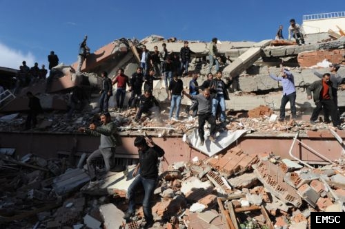
An event of magnitude Mw 7.2 occurred on 2011/10/23 at 10:41:22.0 UTC close to the city of Van in Eastern Turkey. The earthquake took place at shallow depth (10km) on the shore of lake Van. It has been largely felt in Turkey and in the neighbouring countries. More than 600 people died. Around 2000 buildings collapsed and 1350 people have been injured according to the latest reports. The city of Ercis is particularly affected. Rescue teams struggled to help the population and to extract victims from the rubbles. A long serie of aftershocks followed the main quake. More information on the main shock is available here.
On November 9th at 19:23 UTC, a strong 5.7-magnitude earthquake rocked again eastern Turkey, killing at least 7 people and toppled 25 buildings in the city of Van. Rescue workers had managed to pull out 25 survivors from the rubble of three collapsed buildings, including a top hotel where journalists and foreign aid workers were staying, authorities said Thursday. This earthquake is located 40 km south of the M7.2 epicenter that struck this region on October 23rd.
| A video posted by a witness. Video of the security camera in Van, Turkey (30 Km of the epicenter) taken during the shake. |
Earthquake reports
- Evaluation report published by the Bogazici University (Kandilli Observatory and Earthquake Research Institute). Most recent information available on Bogazici University web page (Details on the tectonics, hazard, ground motions and photos of the damages)
- Preliminary report of the METU-EERC and Earthquake Department (AFAD)
- Comparing the current impact of the Van Earthquake to past earthquakes in Eastern Turkey by the CEDIM Forensic Earthquake Analysis Group
- Final report on Van Earthquake by Disaster and Emergency Management Presidency Earthquake Department, Ankara (updated on Dec. 23rd)
Tectonic settings
|
The country lies in a seismically active region. The Arabian plate moves northward relative to Eurasia leads to lateral motion of the The earthquake took place east of the North and East Anatolian faults, on the Bitlis suture zone.
In 2003, an earthquake of magnitude 6.6 occurred on May 1st in Bingol 250km west of Van. On January 27th another earthquake of magnitude 6.1 affected Pülümür, also west of Van. The main event occurring in the vicinity of the Lake took place in November 1976 in Caldiran, about 70km away from Van with a magnitude of 6.3. This seismic event and the severe weather conditions raised the death toll to 3,900 and more than 9,000 buildings were damaged. |
Scheme of the Eurasian-Arabic plate collision (USGS) |

Aftershocks locations
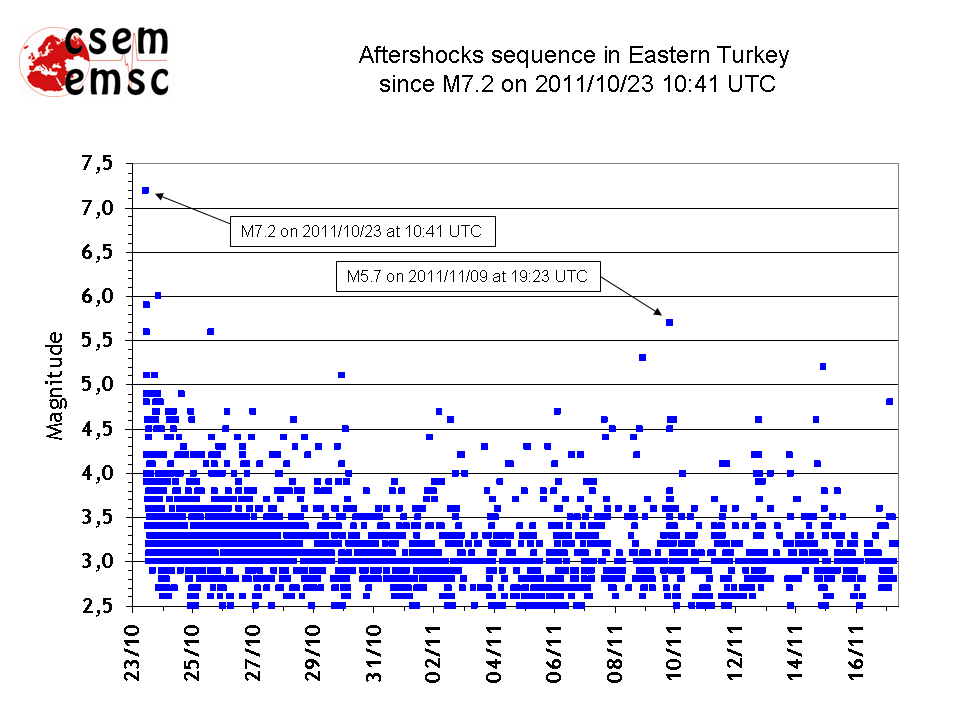
A long serie of aftershocks has followed the main quake. In 72 hours, 7 events of magnitude larger than 5 occurred and more than 570 aftershocks of magnitude larger than 3 were recorded.
 Loading, please wait...
 Download Google Earth/KML file of afterschocks locations (Automatic update - requires an internet connexion)
Aftershocks time distribution
Were you there ?
|
Fill our online questionnaire
If you have experienced this earthquake, you are invited to answer the online questionnaire. Your testimony will be useful to update the Intensity map here below. You can also read the comments posted by people who experienced this event or view them on the interactive map here below.
The results of the questionnaires are used to compute the intensities, which quantifies the effects of an earthquake. A macroseismic intensity map is then computed (Intensities are expressed in EMS-98 scale)
|
Send us pictures or videos
Send your pictures of the damages via RICHTER (free application for Android mobiles). More...
You were on the spot and you have taken photos or videos of earthquake effects (on buildings, ground, landscape), please send us your files. Send them by mail, MMS or upload them directly from your computer. Just click on the link below : |
|
Macroseismic map based on eye-witness reports |
Pictures sent by a eye-witness that show damage in the city of Van |

Further Information
 Iris Teachable moment presentation
Source mechanism
|
focal mechanism and source time function (M. Vallée, GéoAzur, France) |
Moment tensor solutions
|
|
Source mechanism from teleseismic waveform inversion (O. Tan, Tubitak, Turkey) |
Hypothesis of a multiple-point source solution for the Van earthquake based on strong motion data (J. Zahradnik and E. Sokos, CUNI, Prague, Czech Republic and University of Patras, Greece) |


Epicenter location
 Main Shock Epicenter Location |
(1964-1997) and EMSC catalogues (1998-today) |
